Logistics & EconomicsLogistics arithmetic
Silk Road: Richthofen Wrote of Silk Roads by 1877, Plural
Treaties & Tradeoffs Filed
The name “Silk Road” was in print by 1877, when Ferdinand von Richthofen wrote of Seidenstrassen, “silk roads,” on pages 496 to 507 of the first volume of his China, printed in Berlin [1]. The pages we read do not show who used it first; his chapter covers a trade that, by his account, Chinese caravans began to take into their own hands in 114 BC [1]. Measured as straight lines between six places he names, the route from Hierapolis, near the Euphrates, to Xi'an comes to about 6,440 km [1][2].
Order of business (4 sections)
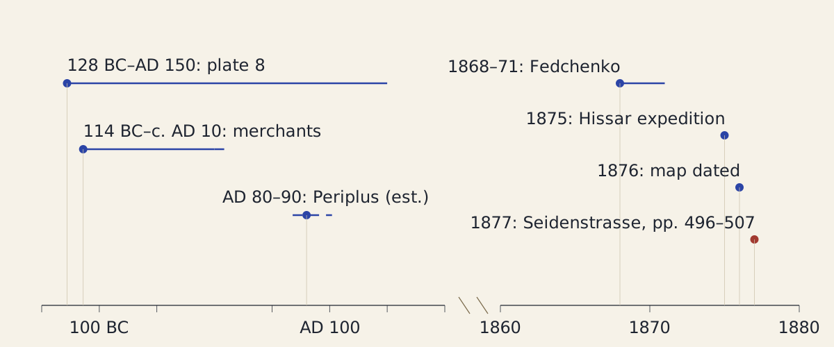
Figure: The dated events in Richthofen's 1877 account of the silk trade, on a broken axis; the dashed marks are approximate dates.
Diagram: Treaties & Tradeoffs. CC BY 4.0. Open full size
Reuse credit
Diagram: Treaties & Tradeoffs, "Silk Road: the trade Richthofen dated and the 1877 volume that named it" — https://treatiesandtradeoffs.com/logistics/silk-road/, CC BY 4.0 (https://creativecommons.org/licenses/by/4.0/)
Data: Dates: Ferdinand von Richthofen, China, vol. 1 (Berlin: Reimer, 1877), pp. 475, 477, 496, 506 and plate 8, Staatsbibliothek zu Berlin digital copy, accessed 2026-11-02, public domain
The timeline as text
- 128 BC to AD 150: the period covered by Richthofen's map of trade links, plate 8 [1].
- 114 BC to about AD 10: Chinese merchants carry the silk trade as far as the Oxus and Yaxartes, by his account [1].
- AD 80 to 90: the Periplus of the Erythraean Sea is written, by Müller's dating as Richthofen gives it [1].
- 1868–71: Fedchenko's journeys between the Oxus and Yaxartes [1].
- 1875: the Hissar expedition [1].
- 1876: the date printed on Richthofen's map, plate 8 [1].
- 1877: volume 1 of China prints Seidenstrasse on pages 496 to 507 [1].
In 1877 Ferdinand von Richthofen (1833–1905) wrote of “silk roads” [1]. He was reconstructing how silk had moved between China and the Roman world, from Chinese annals in translation, from Ptolemy, and from Russian surveys only a few years old [1]. In his account silk changed hands along the way, and the first time the word appears in his chapter it is plural [1]. In the pages read, the single name is in print by 1877, long after the trade it describes.
Who named the Silk Road?
Reported: Volume 1 of Richthofen's China, a work he subtitled as the results of his own journeys and of studies based on them, runs to 758 numbered pages; its tenth chapter traces contact and trade between China and the peoples south and west of Central Asia [1]. On page 496 he writes, in our translation from the 1877 Berlin edition, that “supplementary news about the western part of one of the earlier silk roads” comes again from Marinus, who in this part followed his informant entirely, a man sent out by the Macedonian merchant Maes [1]. The German is einer der früheren Seidenstrassen: one of several, not the only one [1]. Elsewhere in the chapter his headings are plainer, such as “Opening of the road to the west” on page 454, which tells how Chinese armies pushed the Hiungnu back from the approaches to the west between 124 and 119 BC [1].
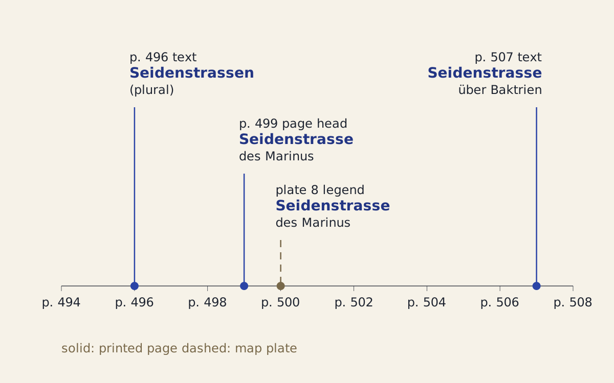
Figure: Where the word appears in the pages read: three places in the printed text and one in the legend of plate 8, bound in at page 500.
Diagram: Treaties & Tradeoffs. CC BY 4.0. Open full size
Reuse credit
Diagram: Treaties & Tradeoffs, "Where Richthofen's 1877 China uses Seidenstrasse" — https://treatiesandtradeoffs.com/logistics/silk-road/, CC BY 4.0 (https://creativecommons.org/licenses/by/4.0/)
Data: Ferdinand von Richthofen, China, vol. 1 (Berlin: Reimer, 1877), pp. 496, 499, 507 and plate 8, Staatsbibliothek zu Berlin digital copy, accessed 2026-11-02, public domain
The pages as text
- Page 496, text: einer der früheren Seidenstrassen, one of the earlier silk roads [1].
- Page 499, page heading: Seidenstrasse des Marinus, Marinus's silk road [1].
- Plate 8, legend, map dated 1876 and placed at page 500: die Seidenstrasse des Marinus [1].
- Page 507, text: die oben betrachtete Seidenstrasse über Baktrien, the silk road through Bactria considered above [1].
Reported: The singular follows on page 499, in the page heading Seidenstrasse des Marinus, and again in the legend of the map that faces page 500, where red names and lines mark “the geography of the land of Serica by Ptolemy and the silk road of Marinus” [1]. On page 507 Richthofen names “the silk road through Bactria considered above” as one of four ways by which the West heard of the silk lands; the others were a trade route through Tibet, the sea route, and a link between Assam and south-western China [1].
Every use found in the pages read, with the German and our translation (CSV) Source and license notes (JSON) Data: Ferdinand von Richthofen, China, vol. 1 (Berlin: Reimer, 1877), pp. 496, 499, 507 and plate 8, Staatsbibliothek zu Berlin digital copy, accessed 2026-11-02, public domain; translations ours
Reported: The word for silk itself had travelled further. Richthofen traces the names western peoples gave the fabric to forms of sir or ser that passed from land to land, and finds the first Mediterranean hint of the root in Nearchos, an officer of Alexander, who called certain fabrics seen in India Seric [1]. From that root came the Seres, the people the silk was thought to come from, and Serica, their land [1].
Assessed: These pages show that the word was in print by 1877. They do not show that Richthofen put it there before anyone else. We read pages 454 to 512 of a long book, and no other writer's usage, so the question of who used the word before him stays open here. The 1877 volume shows the name in use by then; it cannot show whether anyone wrote it earlier in the century, or before 1800.
Which trade was Richthofen describing?
Reported: Richthofen writes that the silk reaching western peoples came to them “through entirely indirect trade connections,” in our translation, and that from 114 BC Chinese caravans began to take the trade into their own hands [1]. Before then, he writes, the overland silk trade was still small, and it reached no further west than India, Persia and Media [1]. In his account, Chinese merchants carried the silk trade as far as the Oxus and the Yaxartes, the two great rivers of Central Asia, from 114 BC into the first decade AD [1]. Westerners probably learned of the Seres, “the silk bringers,” from Parthian traders, he adds [1].
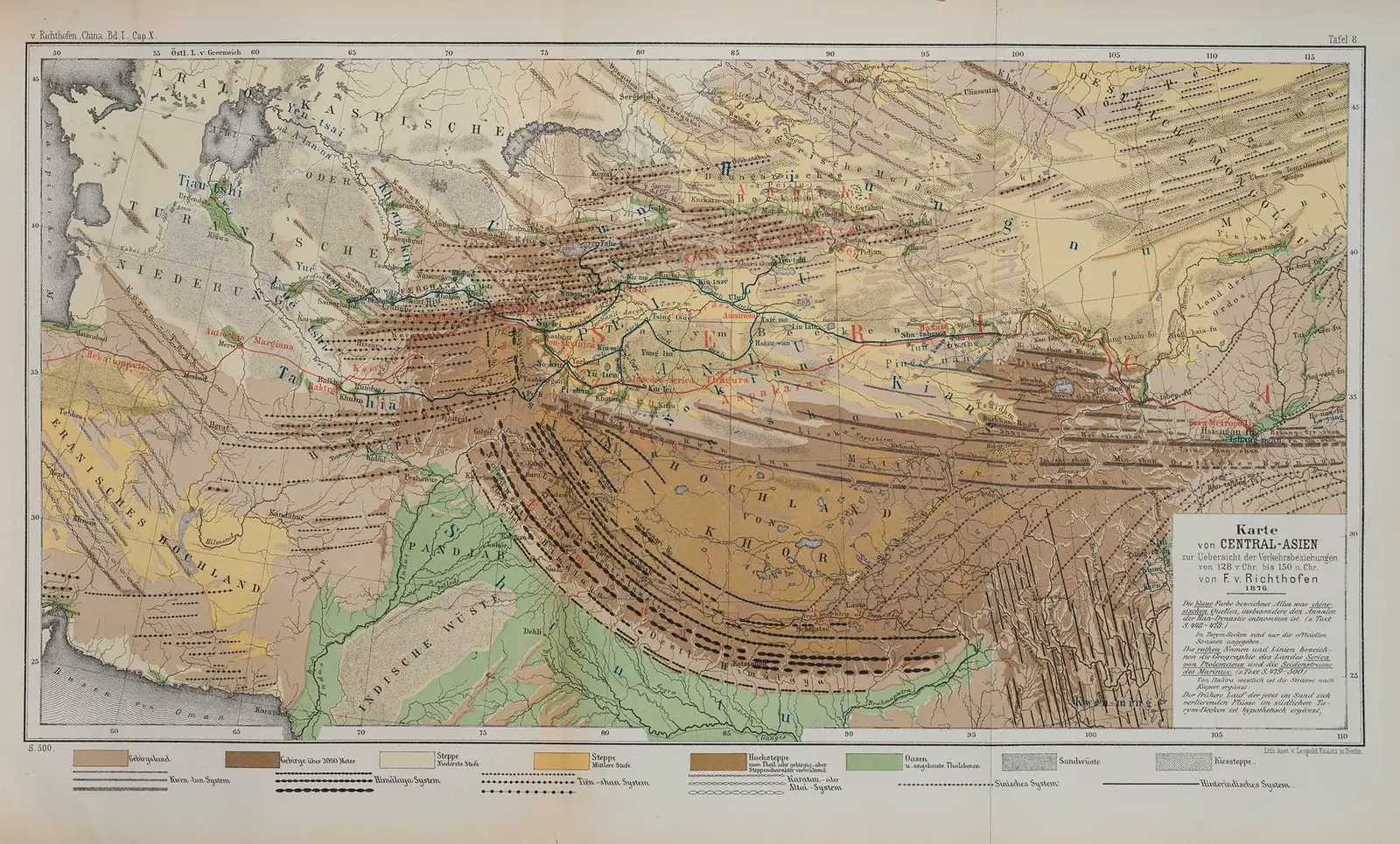
Figure: Richthofen's map of Central Asia for trade links from 128 BC to AD 150, dated 1876 and printed as plate 8 of his 1877 volume; the legend credits the route west of Bactra to Kiepert.
“Karte von Central-Asien zur Uebersicht der Verkehrsbeziehungen von 128 v. Chr. bis 150 n. Chr.” by Ferdinand von Richthofen. Public Domain Mark.
Full credit
"Karte von Central-Asien zur Uebersicht der Verkehrsbeziehungen von 128 v. Chr. bis 150 n. Chr." by Ferdinand von Richthofen — https://commons.wikimedia.org/wiki/File:Map_of_Central_Asia_with_trade_routes_and_movements,_von_Richthofen.png — Public domain (Ferdinand von Richthofen d. 1905; US: published 1877; EU: author died more than 70 years ago; plate 8 of China, vol. 1 (Berlin: Reimer, 1877), marked Public Domain Mark 1.0 on Commons)

Reported: Silk was not the only cargo. Pliny, as Richthofen reports him, listed hides and excellent iron among the goods of the Seres, and complained that India, the Seres and Arabia drew one hundred million sesterces a year out of the Roman empire [1]. Richthofen also quotes the Periplus of the Erythraean Sea, sailing directions for the voyage to India that Müller dated to AD 80 to 90, on raw silk, silk yarn and silk cloth brought overland through Bactria to Barygaza [1].
Assessed: The sum of one hundred million sesterces is Pliny's complaint, not an account book, and it covers three regions at once. We do not turn it into days of wages, because we found no wage series for the same place and period. On Richthofen's own dates, Chinese caravans began to take over the trade 1,990 years before his volume appeared. His map of it was a scholar's reconstruction, not the work of anyone who had carried silk.
The card at the top of this page applies the known-then test: score the choice only on what its makers could know at the time, with each piece of that knowledge tied to a source. Here the choice is a name, and the card lists what Richthofen had in hand when he chose it.
How long was the route?
Method: We took six places that appear in Richthofen's chapter or on his map, under their modern names: Hierapolis (Manbij), near the Euphrates; Merv (Mary); Bactra (Balkh); Kashgar; Dunhuang; and Chang'an (Xi'an) [1]. Their coordinates come from the GeoNames gazetteer, one record per place; the records for Manbij, Mary, Balkh and Xi'an list the old names among their alternates [2]. Letting each modern point stand for the ancient place is our assumption. Each leg is worked out twice: as a great circle on a sphere of radius 6,371.0088 km, and as a geodesic on the WGS84 ellipsoid used for modern maps.
Method: These are straight lines between named places, not the length of any road. That makes them a floor. The six places are a choice: they lie on or near the red and blue lines of his map, but no single traveller in the pages we read passed through all of them.
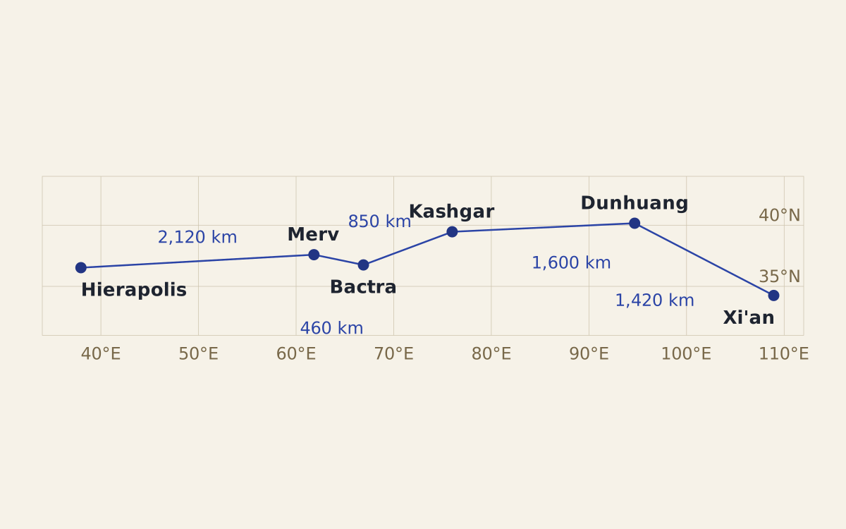
Figure: The six places set by their coordinates, with straight lines between them; there is no scale bar, and the lines are not roads.
Diagram: Treaties & Tradeoffs. CC BY 4.0. Open full size
Reuse credit
Diagram: Treaties & Tradeoffs, "Silk Road: six places by their coordinates" — https://treatiesandtradeoffs.com/logistics/silk-road/, CC BY 4.0 (https://creativecommons.org/licenses/by/4.0/)
Data: Coordinates: GeoNames (geonames.org), records 167357, 1218667, 1147290, 1280849, 1529531, 1790630, accessed 2026-11-02, CC BY 4.0; Place names: Ferdinand von Richthofen, China, vol. 1 (Berlin: Reimer, 1877), public domain
The map as text
- Hierapolis (Manbij): 36.528153°N, 37.954954°E [2].
- Merv (Mary): 37.593785°N, 61.830308°E [2].
- Bactra (Balkh): 36.756352°N, 66.897196°E [2].
- Kashgar: 39.46717657°N, 75.98675345°E [2].
- Dunhuang: 40.1666667°N, 94.6833333°E [2].
- Xi'an (Chang'an): 34.258333°N, 108.928611°E [2].
Reported, with our conversion: The five legs add up to about 6,440 km on the sphere and 6,450 km on the ellipsoid [2]. A single straight line from Hierapolis to Xi'an is about 6,290 km, so passing through the four places in between adds only about 150 km [2].
| Leg | Straight line, km | Coordinates |
|---|---|---|
| Hierapolis to Merv | 2,120 | GeoNames [2] |
| Merv to Bactra | 460 | GeoNames [2] |
| Bactra to Kashgar | 850 | GeoNames [2] |
| Kashgar to Dunhuang | 1,600 | GeoNames [2] |
| Dunhuang to Xi'an | 1,420 | GeoNames [2] |
| Sum of the five legs, from unrounded figures | 6,440 | GeoNames [2] |
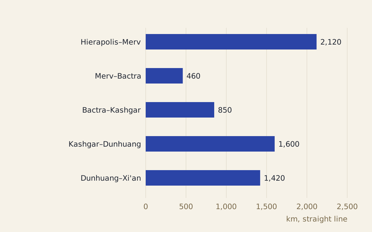
Figure: The five legs of the chain in kilometres, measured on a sphere; the ellipsoid figures in the download differ by less than half a percent.
Diagram: Treaties & Tradeoffs. CC BY 4.0. Open full size
Reuse credit
Diagram: Treaties & Tradeoffs, "Silk Road: five straight-line legs in kilometres" — https://treatiesandtradeoffs.com/logistics/silk-road/, CC BY 4.0 (https://creativecommons.org/licenses/by/4.0/)
Data: Coordinates: GeoNames (geonames.org), accessed 2026-11-02, CC BY 4.0; distances worked out from them
Coordinates and distances, leg by leg (CSV) Source and license notes (JSON) Data: Coordinates: GeoNames (geonames.org), records 167357, 1218667, 1147290, 1280849, 1529531, 1790630, accessed 2026-11-02, CC BY 4.0; Place names: Ferdinand von Richthofen, China, vol. 1 (Berlin: Reimer, 1877), Staatsbibliothek zu Berlin digital copy, accessed 2026-11-02, public domain
Reported: Richthofen's Chinese figures came in li, from the Han annals as translated in his day. He gives Kashgar as 9,350 li from the capital Tshang-ngan, counted by the northern road through Kiu-tsze (7,480 li plus 1,870), and the Tarim basin as 6,000 li long from Sha-tshöu to Kashgar [1]. We take Sha-tshöu to stand at Dunhuang, which is our assumption.
Reported: The annals, Richthofen notes, gave each distance by the shortest road, whether it served great caravans or only smaller traffic [1]. In the early period the road south of the Tarim river was the one most used, and Buddhist pilgrims and later Marco Polo travelled it as well [1]. We leave the li unconverted, since the pages we read give no fixed length for it.
Reported, with our check: The annals put the Dunhuang-to-Kashgar stretch at 0.64 of the capital-to-Kashgar distance (6,000 of 9,350 li). On the coordinates, the straight line from Dunhuang to Kashgar is 0.54 of the straight line from Xi'an to Kashgar, which is about 2,970 km [1][2]. Richthofen also places Tun-hwang, his spelling of Dunhuang, on the meridian of 94½°, and his map counts longitude east of Greenwich; GeoNames puts Dunhuang at 94.68° east, a difference of 0.18° [1][2].
Assessed: The two ratios need not match: the annals counted roads, the 6,000 li is a length of the basin rather than of one road, the coordinates give straight lines, and Sha-tshöu at Dunhuang is our assumption. The comparison shows the order of size, not a conversion; distance is the only arithmetic these pages support. They give no loads, no daily marches and no animals, so we do not estimate how long a caravan took. When Congress lent bonds by the mile for the transcontinental railroad in 1862, distance set the sum; here it only frames the trade.
Did goods travel the whole way?
Reported: Marinus of Tyre, as Richthofen tells it, drew his account of the road beyond Bactra from the merchant Maes, “called Titianus,” who had sent his own men there [1]. That report survives only in Ptolemy's short discussion of it [1]. By that account the road ran north from Bactra to the land of the Komedi, then along the foot of the mountains to where the plain ends in a gorge, and from there 50 schoeni, a caravan measure of road, north to the Stone Tower [1].
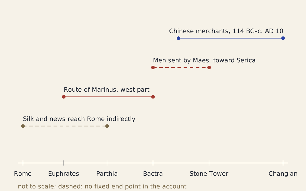
Figure: Who carried silk or news over which stretch, in Richthofen's account; not to scale, and the dashed stretches have no fixed end in the account.
Diagram: Treaties & Tradeoffs. CC BY 4.0. Open full size
Reuse credit
Diagram: Treaties & Tradeoffs, "Silk Road: who carried which stretch, by Richthofen's account" — https://treatiesandtradeoffs.com/logistics/silk-road/, CC BY 4.0 (https://creativecommons.org/licenses/by/4.0/)
Data: Ferdinand von Richthofen, China, vol. 1 (Berlin: Reimer, 1877), pp. 474–478 and 496–497, Staatsbibliothek zu Berlin digital copy, accessed 2026-11-02, public domain
The stretches as text
- Chinese merchants, from Chang'an to the Oxus and Yaxartes, 114 BC to about AD 10 [1].
- Men sent by Maes, from Bactra toward Serica, past the Stone Tower [1].
- The western part of Marinus's route, from the ferry near Hierapolis on the upper Euphrates to Bactra [1].
- Silk and news of the Seres reaching Rome indirectly, probably through Parthian traders [1].
Reported: After the campaigns of the general Pan-tshau, Richthofen writes, the Chinese again took the part of the Seres and favoured trade: they let in those who came to do business, though probably only by roads set aside for them and to certain places [1].
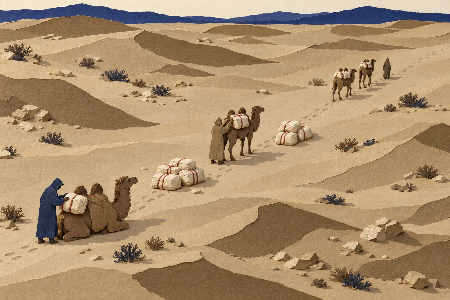
Figure: Silk in stages: in Richthofen's account, goods passed through several hands on the way west.
Illustration: Treaties & Tradeoffs. Generated schematic image — not a photograph or historical record. © Treaties & Tradeoffs, all rights reserved.
Reported: The pages we read describe no carrier who went from China to Rome. In his account, Chinese merchants went as far as the Oxus and Yaxartes, Maes sent his men, and western writers had only hazy, half-legendary knowledge of the Seres [1].
Assessed: On Richthofen's evidence, the trade was a chain of shorter stretches handled by different people, and his chapter speaks of silk roads in the plural on page 496, before the singular on page 499. A single “Silk Road” runs these stretches together into one route that his pages do not describe. The 6,440 km is the frame around that chain, not a journey anyone in his sources made. A sum of loads needs what these pages lack, and for that the Roman legion's grain is the better guide.
Sources
- Ferdinand von Richthofen, China: Ergebnisse eigener Reisen und darauf gegründeter Studien, vol. 1, Einleitender Theil (Berlin: Dietrich Reimer, 1877), chapter 10, pp. 454–512, and plate 8. Digital copy, Staatsbibliothek zu Berlin, PPN647535718. https://digital.staatsbibliothek-berlin.de/werkansicht?PPN=PPN647535718Read: full text of pp. 454–512 and the map plate; German quotations in our translation
- GeoNames geographical database, records 167357 (Manbij), 1218667 (Mary), 1147290 (Balkh), 1280849 (Kashgar), 1529531 (Dunhuang) and 1790630 (Xi'an). https://www.geonames.org/Read: the six place records
Cite this page
Treaties & Tradeoffs. “Silk Road: Richthofen Wrote of Silk Roads by 1877, Plural.” published 2026-11-02. https://treatiesandtradeoffs.com/logistics/silk-road/. Accessed [the date you read it].
Plain citation; add the date you consulted the page. No DOI is assigned.