Patterns in StrategyCase review
Maginot Line: It Pushed Germany to Belgium, Seramour Argues
Treaties & Tradeoffs Filed
The Maginot Line did the job it was given, the historian Michaël Seramour argues in the French defence ministry's history journal (2007): it shut the invasion routes through Lorraine and Alsace and forced the German army back onto the Belgian plains, as in 1914. On 10 May 1940 the Allied armies marched into Belgium to meet that attack, Max Schiavon writes (2011), and from 13 May the first reports came in that German troops might have crossed the Meuse between Namur and Sedan [4][5].
Order of business (5 sections)
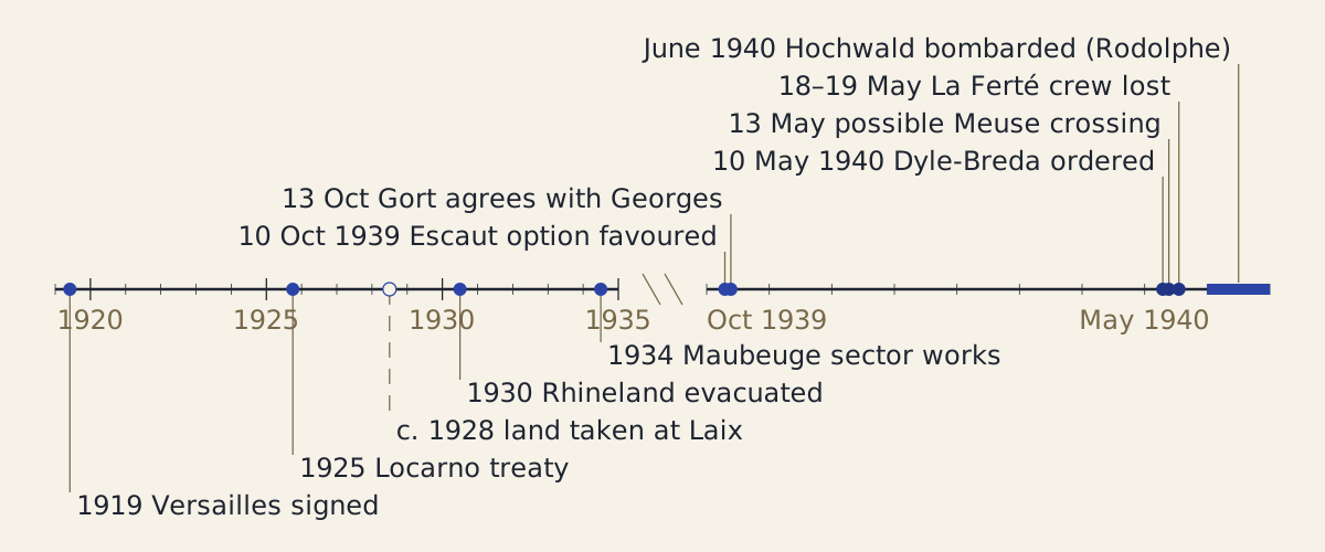
Figure: From the Versailles treaty to the fighting of 1940, in two stretches: years from 1919 to 1935, then months from October 1939 to June 1940; the hollow mark is an approximate year.
Diagram: Treaties & Tradeoffs. CC BY 4.0. Open full size
Reuse credit
Diagram: Treaties & Tradeoffs, "From Versailles to May 1940: a timeline" — https://treatiesandtradeoffs.com/patterns/maginot-line/, CC BY 4.0 (https://creativecommons.org/licenses/by/4.0/)
Data: Treaty of Versailles, 28 June 1919, and Locarno treaty, 16 October 1925, texts at the Avalon Project, accessed 2026-11-02, official treaty texts, public domain; Michaël Seramour (2007), Max Schiavon (2011) and Emmanuel Pénicaut (2009), Revue historique des armées, OpenEdition, accessed 2026-11-02, dates only, copyright the publisher, all rights reserved
The timeline as text
- 28 June 1919: the Treaty of Versailles bars German fortifications on the left bank of the Rhine and in a strip 50 km east of it, and puts the left bank under Allied occupation for 15 years from the treaty's coming into force [1][2].
- 16 October 1925: at Locarno, Germany, Belgium, France, Great Britain and Italy conclude a treaty guaranteeing the German–Belgian and German–French frontiers [3].
- About 1928: land is taken for a casemate at Laix, 40 years before farmers bought it back in 1968 [4].
- 1930: the Rhineland is evacuated, as Pénicaut dates it [6].
- 1934: General Forceville supervises the building of the works of the fortified sector of Maubeuge, near the Belgian frontier [4].
- 10 October 1939: Generals Georges and Billotte favour only the Escaut option for the move into Belgium [5].
- 13 October 1939: Gort, commanding the British Expeditionary Force, agrees with Georges [5].
- 10 May 1940: German forces enter the Netherlands, Belgium and Luxembourg; Gamelin orders the Dyle-Breda plan [5].
- 13 May 1940: first reports reach the British command that German troops may have crossed the Meuse between Namur and Sedan [5].
- Night of 18–19 May 1940: 107 men of the crew of La Ferté, in the Ardennes, die by asphyxiation [4].
- June 1940: Stukas and a 420 mm mortar bombard the works of Hochwald and Schoenenbourg, in the 1949 account of Lieutenant-Colonel Rodolphe that Seramour cites [4].
The timeline with a source for each row (CSV) Source and license notes (JSON) Data: Treaty of Versailles, 28 June 1919, and Locarno treaty, 16 October 1925, texts at the Avalon Project, accessed 2026-11-02, official treaty texts, public domain; Michaël Seramour (2007), Max Schiavon (2011) and Emmanuel Pénicaut (2009), Revue historique des armées, OpenEdition, accessed 2026-11-02, facts paraphrased, copyright the publisher, all rights reserved
On 10 May 1940, with German troops entering Belgium, Gamelin ordered the Allied armies forward to meet them. Hundreds of thousands of French and British soldiers set off toward a line running from Antwerp through Namur to Sedan, Schiavon writes [5]. Behind them, facing Germany, stood the Maginot Line. In Seramour's reading, the concrete had already done its part by sending the attack north, into Belgium [4].
What was the Maginot Line meant to do?
Reported: Seramour wrote his article, a history of the line from 1945 to the present, for the Revue historique des armées, the journal of the French defence ministry's historical service [4]. He was then a doctoral candidate at the University of Metz, and the article condenses his master's research there [4]. His subject is the line after 1945. He opens, though, with a judgment on 1940.
Reported: In that judgment the line, which he calls the shield of France, filled its role of deterrence and defence [4]. By blocking the invasion routes through Lorraine and Alsace, he writes, it forced the German army onto the Belgian plains, as in 1914 [4]. On the Rhine and in the Saar it held up two German armies with a minimum of troops, and the works that came under attack fought hard for the few square kilometres given to them [4].
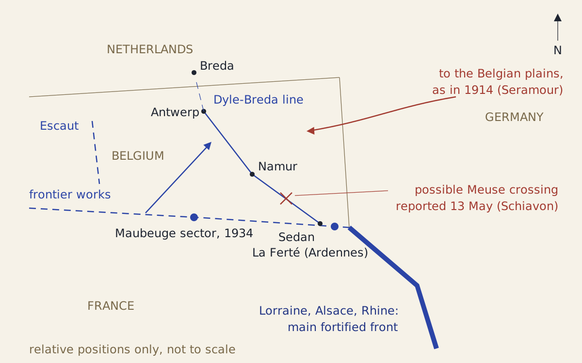
Figure: A schematic of where the pieces sat relative to one another: the main fortified front, the works Seramour names near the Belgian frontier, the two Allied lines in Belgium and the German route that Seramour describes; not to scale.
Diagram: Treaties & Tradeoffs. CC BY 4.0. Open full size
Reuse credit
Diagram: Treaties & Tradeoffs, "The Maginot Line and the Belgian front: a schematic of relative positions" — https://treatiesandtradeoffs.com/patterns/maginot-line/, CC BY 4.0 (https://creativecommons.org/licenses/by/4.0/)
Data: Michaël Seramour (2007) and Max Schiavon (2011), Revue historique des armées, OpenEdition, accessed 2026-11-02, place names and positions only, copyright the publisher, all rights reserved
The positions as text
- Lorraine, Alsace and the Rhine: the main fortified front, facing Germany [4].
- Near the Belgian frontier: works Seramour names, the fortified sector of Maubeuge (under construction in 1934) and the small work of La Ferté in the Ardennes [4].
- German route in 1940, in Seramour's account: onto the Belgian plains, as in 1914 [4].
- Escaut: the shallow option, a small part of Belgium [5].
- Antwerp–Namur–Sedan, with an extension to Breda in Holland: the Dyle-Breda line [5].
- Meuse between Namur and Sedan: first reports of a possible German crossing, 13 May 1940 [5].
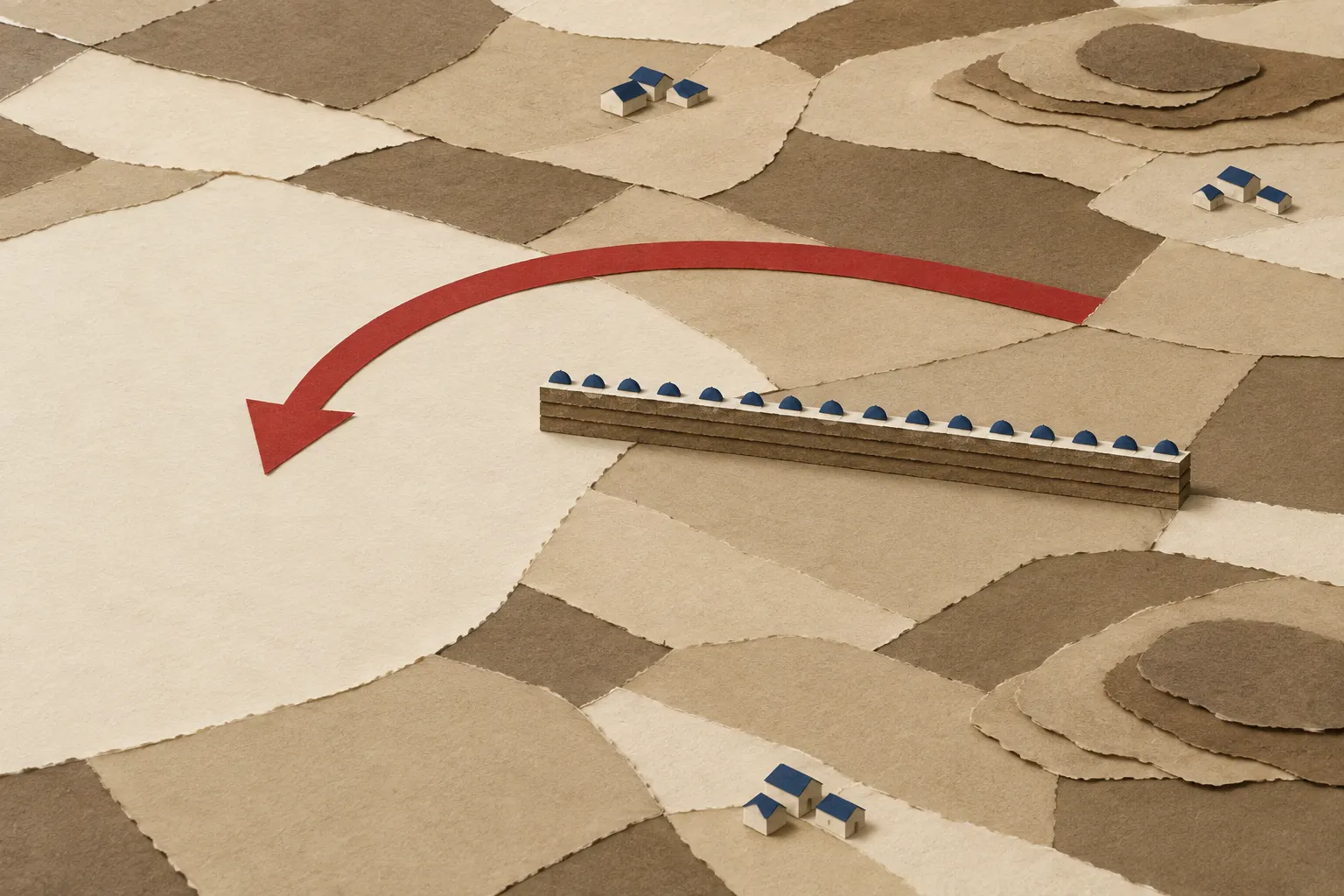
Figure: A cut-paper sketch of the argument that the wall turned the attack aside, not a picture of any real plan.
Illustration: Treaties & Tradeoffs. Generated schematic image — not a photograph or historical record. © Treaties & Tradeoffs, all rights reserved.
Reported: The fortified works did not stop dead at the Belgian border in the sources read here. In a note, Seramour records that General Forceville supervised the building of the fortified sector of Maubeuge, near the Belgian frontier, in 1934 [4]. He also names a small work at La Ferté, in the Ardennes [4]. The sources we read do not compare these works with the ones facing Germany, or say why they were built where they were, so this page does not offer a reason.
Reported: One later document uses the language of steering. When the army's chief of staff stopped treating the north-east fortifications as a defensive position on 17 October 1960, Seramour reports, he described the role they would no longer play: denying ground by fire, or channelling the enemy's advance [4].
Assessed: Seramour's case is about what the line achieved, not about what its builders wrote down. His article cites no planning papers from the 1920s for it, and the law that funded the works was not among the documents we could read. So this page treats “meant to push Germany into Belgium” as his argument about the line's effect, not as a documented intention.
What did France know before the war?
Reported: The Treaty of Versailles, signed on 28 June 1919, forbade Germany “to maintain or construct any fortifications either on the left bank of the Rhine or on the right bank to the west of a line drawn 50 kilometres to the East of the Rhine” [1]. Troops could not be kept or gathered there either, and any breach would count as “a hostile act” against the signatories [1]. Allied troops were to occupy the German left bank for 15 years from the treaty's coming into force [2].
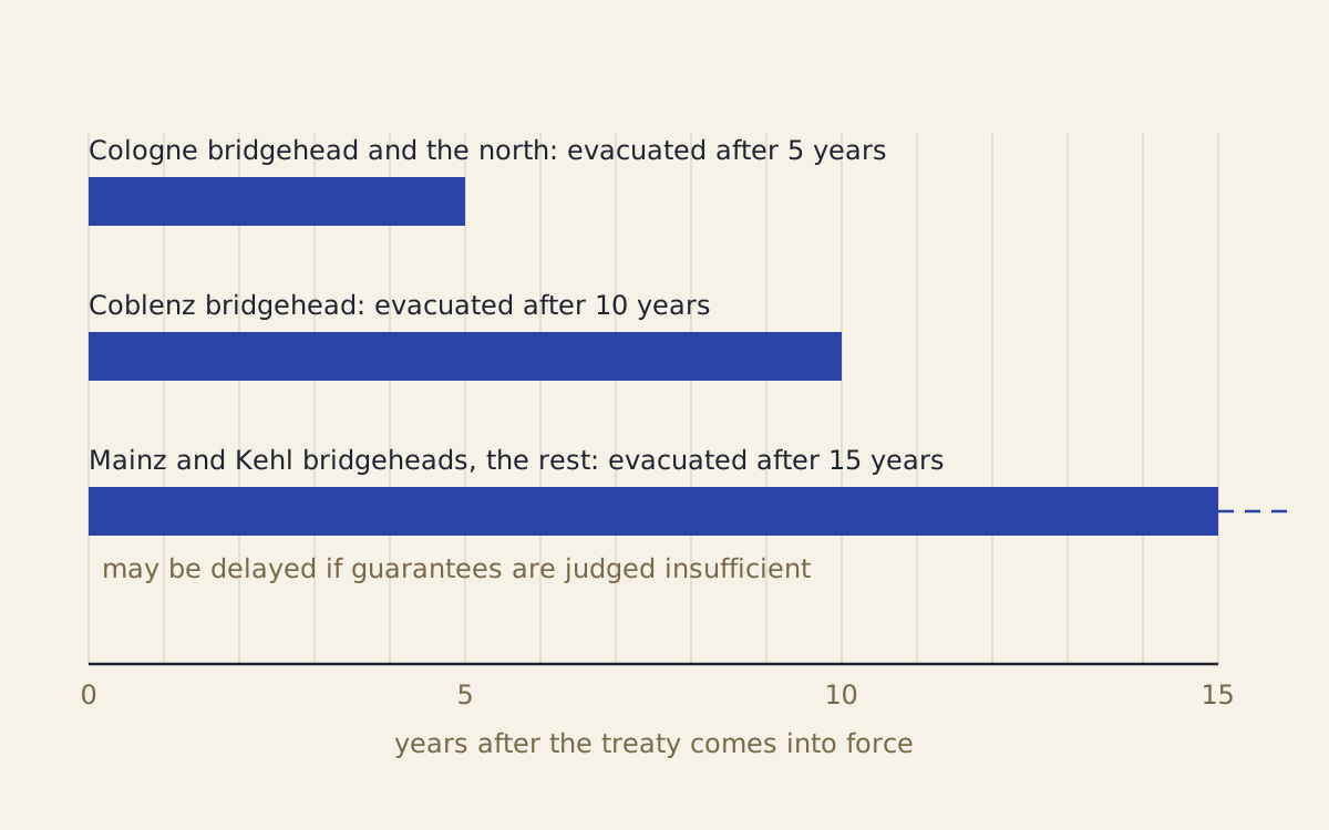
Figure: The schedule in Article 429 of the Versailles treaty for handing back the occupied Rhineland, counted in years from the treaty's coming into force; the dashed end marks the clause allowing delay.
Diagram: Treaties & Tradeoffs. CC BY 4.0. Open full size
Reuse credit
Diagram: Treaties & Tradeoffs, "Versailles Article 429: the Rhineland handover schedule" — https://treatiesandtradeoffs.com/patterns/maginot-line/, CC BY 4.0 (https://creativecommons.org/licenses/by/4.0/)
Data: Treaty of Peace with Germany (Versailles), 28 June 1919, Articles 428–431, text at the Avalon Project, accessed 2026-11-02, official treaty text, public domain
Reported: Article 429 set the handover in three steps: the Cologne bridgehead and the territory north of a line running from the Ruhr to Sinzig on the Rhine after 5 years, the Coblenz bridgehead after 10, and the Mainz and Kehl bridgeheads with the rest after 15 [2]. Each step depended on Germany carrying out the treaty, and the last could be delayed if the Allies judged the guarantees against German aggression insufficient [2]. Article 431 allowed an earlier withdrawal if Germany met all its obligations [2].
The Article 429 schedule, step by step (CSV) Source and license notes (JSON) Data: Treaty of Peace with Germany (Versailles), 28 June 1919, Article 429, text at the Avalon Project, accessed 2026-11-02, official treaty text, public domain
Reported: In the treaty done at Locarno on 16 October 1925, Germany, Belgium, France, Great Britain and Italy jointly guaranteed the frontiers between Germany and Belgium and between Germany and France, along with the demilitarised zone [3]. It was to enter into force once all the ratifications were deposited and Germany had joined the League of Nations [3]. Germany promised Belgium and France that it would not attack or invade them, and they promised the same in return [3]. The preamble also took note of “the abrogation of the treaties for the neutralisation of Belgium” [3].
Reported: Emmanuel Pénicaut, writing in the same journal in 2009, dates the evacuation of the Rhineland to 1930 [6]. With its pledges in Germany gone, he writes, France could no longer justify its protective force in the Saar, and the last French and Belgian detachments left the territory on 12 December 1930 [6].
Reported, with our check: Seramour gives one clue to when building began. When the casemate of Laix was sold at auction on 7 November 1968, he writes, farmers bought back plots taken from them 40 years earlier [4]. That puts the taking of the land at about 1928, by our subtraction.
Assessed: So a planner in the late 1920s knew three things from documents we can read. Germany could not fortify the Rhineland, Allied troops were due to leave it in stages, and the Belgian–German frontier was guaranteed by treaty, though the treaties that had made Belgium neutral were gone. A wall along the German frontier answered an attack straight across it; whether its planners wanted the next attack to go through Belgium, the sources we read do not say.
What did Gamelin decide on 10 May 1940?
Reported: Schiavon, a doctor of history who headed the studies and teaching division of the defence ministry's historical service, writes that the plan for the move into Belgium occupied the whole of the Phoney War [5]. Over the months, Gamelin, the French commander-in-chief, chose an ever more ambitious move that would carry the Allied armies as far as Holland, the Dyle-Breda plan [5]. His subordinates were more cautious [5].
Reported: On 10 October 1939, General Georges, Gamelin's deputy for the north-east front, and General Billotte, commanding the 1st Army Group, compared views and found they agreed [5]. Both favoured only the Escaut option, which meant occupying a small part of Belgium to keep the enemy from the ports. Georges noted in his diary the danger of an encounter battle, meaning a fight with the Germans before the French had time to organise a defensive front [5]. Three days later Gort, commanding the British Expeditionary Force, approved Georges's view entirely [5].
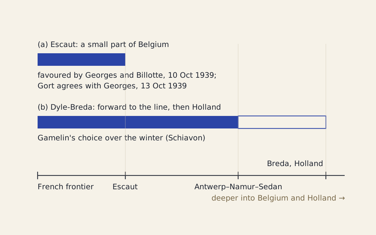
Figure: The two options for the advance into Belgium as Schiavon describes them, measured by how far each would carry the Allied armies from the French frontier.
Diagram: Treaties & Tradeoffs. CC BY 4.0. Open full size
Reuse credit
Diagram: Treaties & Tradeoffs, "Escaut or Dyle-Breda: two options for the move into Belgium" — https://treatiesandtradeoffs.com/patterns/maginot-line/, CC BY 4.0 (https://creativecommons.org/licenses/by/4.0/)
Data: Max Schiavon, Revue historique des armées 264 (2011), OpenEdition, accessed 2026-11-02, facts only, copyright the publisher, all rights reserved
The options as text
- Option (a), Escaut: occupy a small part of Belgium to keep the enemy from the ports; favoured by Georges and Billotte on 10 October 1939; Gort agreed with Georges three days later [5].
- Option (b), Dyle-Breda: carry the Allied armies forward to a line Antwerp–Namur–Sedan and on toward Holland; Gamelin's choice over the following months [5].
Reported: The French command was itself divided that winter. In December 1939 and January 1940, Schiavon writes, a crisis broke out between Gamelin and Georges: Gamelin gave Georges the title of commander of the north-east front without the means to carry out the task, and even took some away [5]. The British, he adds, watched the quarrel closely and kept out of it [5].
Reported: In the months before the attack, Schiavon writes, the senior British officers under Gort seem to have spotted the main weakness of the plan: it lacked a mass of manoeuvre, that is, a large force held back to strike where needed [5]. On 10 May the Germans entered the Netherlands, Belgium and Luxembourg, and Gamelin ordered the Dyle-Breda plan into action [5]. By the evening of 12 May the British force held its 25 km of front on three positions [5]. From 13 May, the first reports reached the British command that the Germans might have crossed the Meuse between Namur and Sedan [5].
Did Gamelin know enough to choose depth?
The card at the top of this page applies what this site calls the known-then test: score the choice only on what its makers could know at the time, with each piece of that knowledge tied to a source. You are at French headquarters on 10 May 1940. German troops are crossing the Belgian border, the plan for this day has been argued over for seven months, and your two senior commanders preferred the shorter move.
Assessed: On that card the plan already took the move into Belgium for granted. What was open was depth, and the risk of the deep move had been named in writing: Georges wrote in his diary in October 1939 of the danger of a battle fought before a front was ready, and British officers appear to have seen before May that the plan lacked a mass of manoeuvre [5]. The sources we read do not give Gamelin's own reasons, so this page does not score them. The danger was on record before the attack began, not something seen only afterwards; whether Georges's note or the British doubts reached Gamelin, the sources we read do not say.
Did the Maginot Line fail?
Reported: Before the war, Seramour writes, French opinion placed an almost religious confidence in the line [4]. After the defeat it became a scapegoat: a wall that had cost billions and served no purpose, and some went as far as to claim the enemy had broken it [4].
Reported: His answer is a count. In the north-east, he writes, the defensive system passed to the German army in 1940 “intact,” a word he puts in quotation marks himself: some 53 works, 323 CORF blocks and many small MOM blockhouses [4]. CORF blocks belonged to the main line of resistance and were designed by the commission that organised the fortified regions; MOM blockhouses were added by army labour between 1935 and 1940 [4]. At the ceasefire, he writes, 25,000 undefeated men were still holding their positions at the gates of Germany [4].
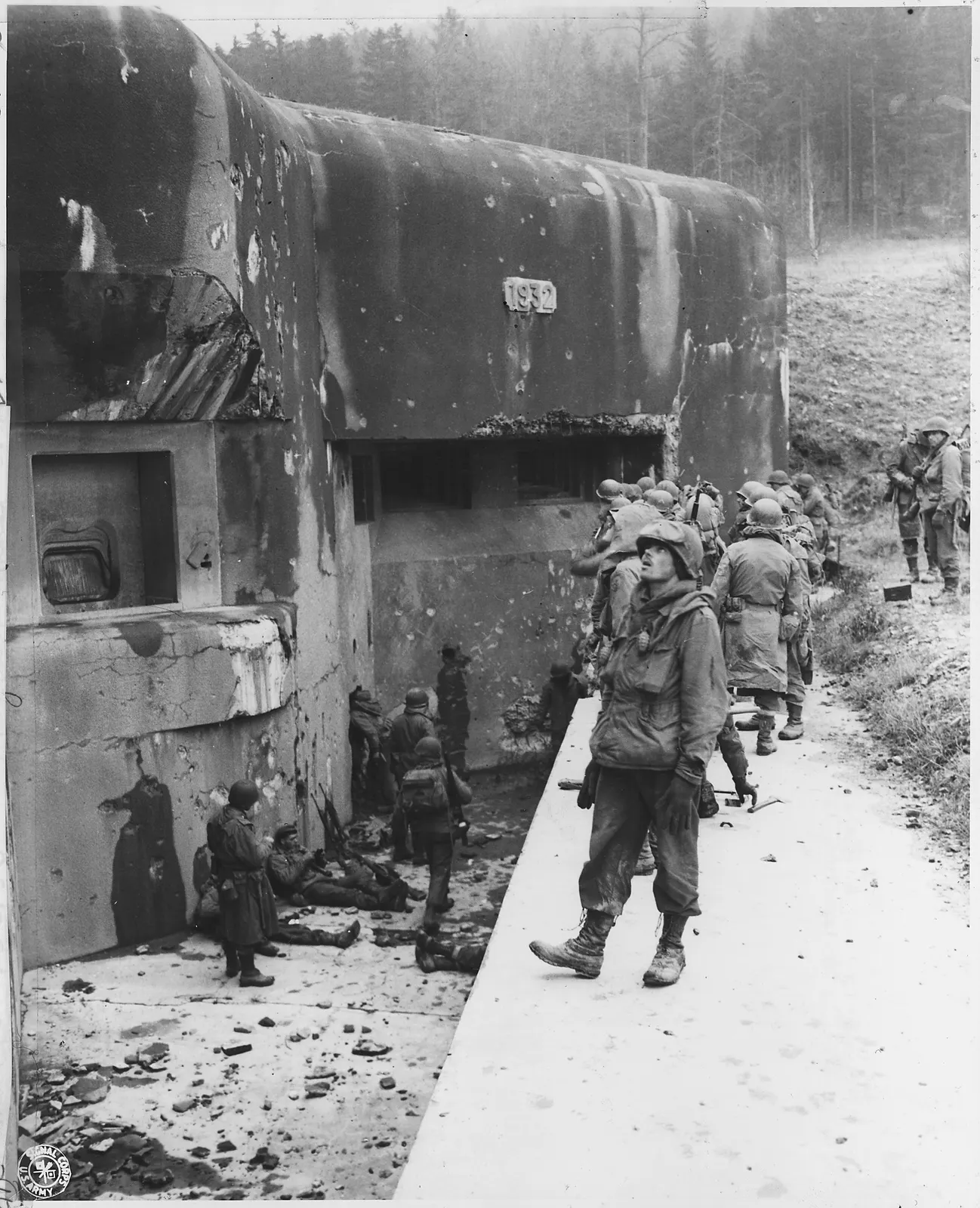
Figure: Seventh Army soldiers wait at the entrance and in the pit of a Maginot Line fort near Climbach, France, on 15 December 1944 (US Army Signal Corps photograph, US National Archives 292568).
“American soldiers at the Maginot Line” by U.S. Army Signal Corps. Public domain.
Full credit
"American soldiers at the Maginot Line" by U.S. Army Signal Corps — https://commons.wikimedia.org/wiki/File:American_soldiers_at_the_Maginot_Line_-_NARA_-_292568.jpg — Public domain (U.S. federal government work, 17 U.S.C. §105; US Army Signal Corps photograph, National Archives Identifier 292568 (Record Group 338, Ft Leavenworth Signal Corps Photograph Collection, NRE-338-FTL(EF)-703(1)))

| Popular version | Where it appears | What the record shows |
|---|---|---|
| The line served no purpose | French opinion after 1940, as Seramour describes it [4] | Seramour argues it blocked Lorraine and Alsace and forced the attack onto the Belgian plains [4] |
| The enemy broke the line | Some in France after the defeat, as Seramour describes them [4] | Handed over “intact” in the north-east, with 25,000 men at the ceasefire (Seramour) [4]; from 13 May the first reports were of a possible German crossing of the Meuse between Namur and Sedan [5] |
| The line was impregnable | The press in 1939 and French opinion before the war, as Seramour describes them [4] | 107 of the crew of La Ferté died on the night of 18–19 May 1940; by Rodolphe's 1949 account, Hochwald and Schoenenbourg were bombarded in June 1940 [4] |
| The line cost billions | French opinion after 1940, as Seramour describes it [4] | No total cost appears in the sources read here; the figure is missing, so none is given |
The popular versions and the record, with sources (CSV) Source and license notes (JSON) Data: Michaël Seramour (2007) and Max Schiavon (2011), Revue historique des armées, OpenEdition, accessed 2026-11-02, facts and claims paraphrased, copyright the publisher, all rights reserved
Reported: The French army did not write the line off in 1940 either, by Seramour's account. In the first years of the Cold War it repaired the works and then set out to modernise them, so that they could hold the Red Army in place in a non-nuclear attack [4]. NATO showed no interest, work slowed from 1955, and in his account France's first atomic bomb, in 1960, ended the programme [4]. On 20 June 1960 the army staff declared that the north-east fortifications had no further role in NATO's plans [4].
Method: We give no cost for the line, because none of the sources we could read states one. For the same reason there is no wage-day conversion on this page: there is no price to convert.
Assessed: On Seramour's evidence, “the Maginot Line failed” mixes up two claims. By his count much of the line held where it stood, but the campaign was lost elsewhere, on the Meuse and in Belgium. That is a narrower defence than “the line worked,” and it rests on one historian's account of 1940 in an article mainly about the years after it.
Where does the pattern break?
Assessed: The pattern this page tests is that a fortified line can succeed at its own task and still not decide the campaign, because its success moves the decisive fight somewhere else. The Maginot Line fits it on Seramour's reading: the attack went round, through Belgium and across the Meuse [4][5]. The matrix below sets each task he names against the other record read here.
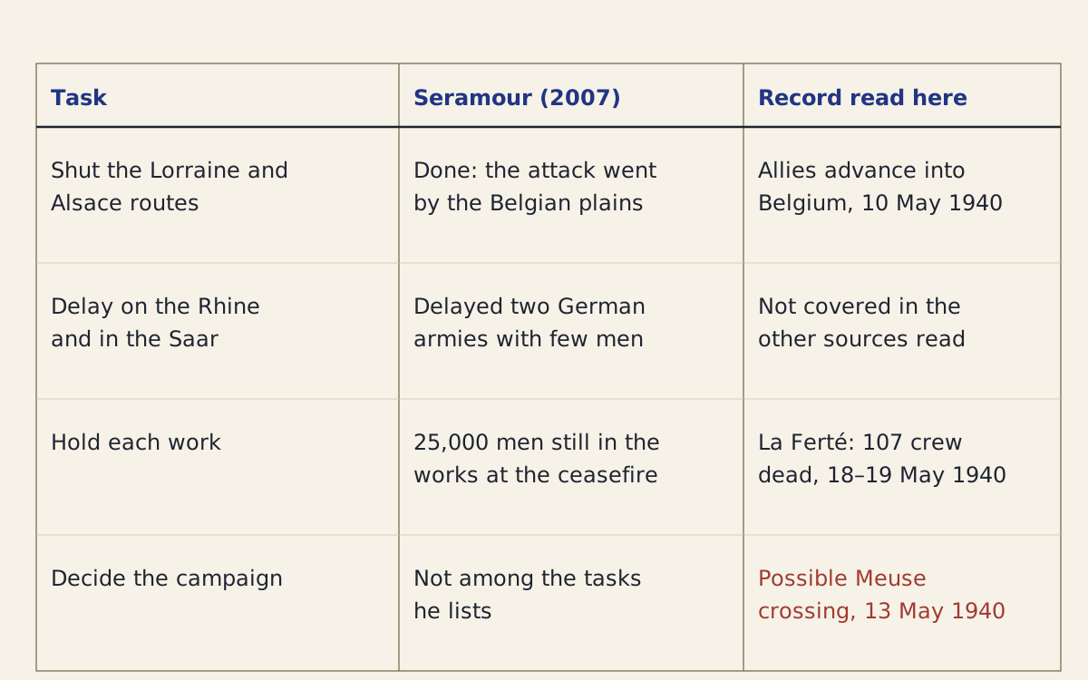
Figure: The tasks Seramour gives the Maginot Line, his account of each, and the record read here, with a last row for the campaign itself.
Diagram: Treaties & Tradeoffs. CC BY 4.0. Open full size
Reuse credit
Diagram: Treaties & Tradeoffs, "The Maginot Line's tasks against the record" — https://treatiesandtradeoffs.com/patterns/maginot-line/, CC BY 4.0 (https://creativecommons.org/licenses/by/4.0/)
Data: Michaël Seramour (2007) and Max Schiavon (2011), Revue historique des armées, OpenEdition, accessed 2026-11-02, facts paraphrased, copyright the publisher, all rights reserved
The matrix as text
- Shut the Lorraine and Alsace routes. Seramour: done; the attack went by the Belgian plains [4]. Record: the Allies advanced into Belgium on 10 May 1940 [5].
- Delay on the Rhine and in the Saar. Seramour: two German armies held up with few men [4]. Record: not covered in the other sources read.
- Hold each work. Seramour: 25,000 men still in the works at the ceasefire [4]. Record, also in Seramour: 107 of the crew of La Ferté died on the night of 18–19 May 1940 [4].
- Decide the campaign. Seramour: not among the tasks he lists [4]. Record: from 13 May 1940, reports that German troops might have crossed the Meuse between Namur and Sedan [5].
Assessed: The first limit is that a line holds only where it is strong. La Ferté was a small work in the Ardennes, and 107 of its crew died by asphyxiation on the night of 18–19 May 1940 [4]. In June 1940, by the account of Lieutenant-Colonel Rodolphe that Seramour cites, Stukas and a 420 mm mortar bombarded the works of Hochwald and Schoenenbourg [4]. Planners in the 1950s cited that account as proof of how solid the system was, which shows the same events can be read either way [4].
Assessed: The second limit is the source. Seramour places himself in what he calls a historiography of rehabilitation, built on the work of the journalist Roger Bruge, whose first volume appeared in 1973, and on the technical studies of Philippe Truttmann and Jean-Yves Mary [4]. His reading of 1940 belongs to that school; his own research covers the years after 1945. A pattern drawn from one side of an argument needs the other side before it can carry much weight, and the readable sources here do not supply it.
Assessed: The third limit is time. A line buys time. It does not say how that time will be used. Rome's delay under Fabius in 217 BC is another defence judged mainly by what came after it, as the Fabian strategy replay shows.
Assessed: The sources read here do not say how much time, if any, the concrete bought the Allies in 1940. They do record how the armies were used: in an advance that, by Schiavon's account, lacked a mass of manoeuvre [5]. Blaming the concrete for that choice is where what this site calls the hindsight premium does most of its work: the share of a decision's apparent wisdom or folly that is added only after the outcome is known. Some 26 years after 1914, the attack came by the Belgian plains again, which is the result Seramour credits to the line [4].
Sources
- Treaty of Peace with Germany (Treaty of Versailles), signed 28 June 1919, Part III, Section III (Left Bank of the Rhine), Articles 42–44. https://avalon.law.yale.edu/imt/partiii.aspRead: full text of Articles 42–44
- Treaty of Peace with Germany (Treaty of Versailles), signed 28 June 1919, Part XIV, Section I (Western Europe), Articles 428–431. https://avalon.law.yale.edu/imt/partxiv.aspRead: full text of Articles 428–432
- Treaty of Mutual Guarantee between Germany, Belgium, France, Great Britain and Italy (the Locarno Pact), signed 16 October 1925. https://avalon.law.yale.edu/20th_century/locarno_001.aspRead: full text of the preamble and Articles 1–4
- Michaël Seramour, “Histoire de la ligne Maginot de 1945 à nos jours,” Revue historique des armées 247 (2007): 86–97. https://journals.openedition.org/rha/1933Read: full text of the article (in French)
- Max Schiavon, “Les relations entre hauts commandements français et britannique en 1939–1940,” Revue historique des armées 264 (2011). https://journals.openedition.org/rha/7282Read: full text of the article (in French)
- Emmanuel Pénicaut, “L’armée française en Sarre, 1918–1930,” Revue historique des armées 254 (2009): 20–28. https://journals.openedition.org/rha/6363Read: full text of the article (in French)
Cite this page
Treaties & Tradeoffs. “Maginot Line: It Pushed Germany to Belgium, Seramour Argues.” published 2026-11-02. https://treatiesandtradeoffs.com/patterns/maginot-line/. Accessed [the date you read it].
Plain citation; add the date you consulted the page. No DOI is assigned.